
Thank you for supporting this site ❤️
Make a donation
Make a donation
Moroleón topographic map
Click on the map to display elevation.
Thank you for supporting this site ❤️
Make a donation
Make a donation
Moroleón
La mancha urbana está situada en la parte baja del municipio y que también es la zona más llana, donde la altitud sobre el nivel del mar va de los 1800 a 1850 metros.
Thank you for supporting this site ❤️
Make a donation
Make a donation
About this map
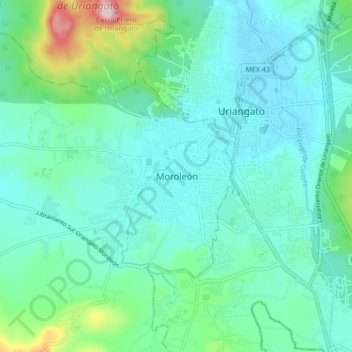
Name: Moroleón topographic map, elevation, terrain.
Location: Moroleón, Guanajuato, 38850, México (20.08627 -101.23372 20.16627 -101.15372)
Average elevation: 1,869 m
Minimum elevation: 1,790 m
Maximum elevation: 2,213 m
Thank you for supporting this site ❤️
Make a donation
Make a donation
Other topographic maps
Click on a map to view its topography, its elevation and its terrain.