
Make a donation
Los Lagos Region topographic map
Click on the map to display elevation.
Make a donation
About this map
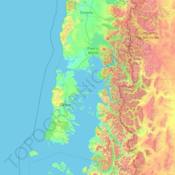
Name: Los Lagos Region topographic map, elevation, terrain.
Location: Los Lagos Region, Chile (-44.06576 -74.84554 -40.23715 -71.58085)
Average elevation: 426 m
Minimum elevation: -1 m
Maximum elevation: 3,127 m
Make a donation
Other topographic maps
Click on a map to view its topography, its elevation and its terrain.
Rinconada
Chile > Santiago Metropolitan Region > Provincia de Talagante > El Monte > El Paico Alto
Average elevation: 445 m
Chicureo
Chile > Santiago Metropolitan Region > Provincia de Chacabuco > Colina
Average elevation: 711 m
Montenegro
Chile > Santiago Metropolitan Region > Provincia de Chacabuco > Tiltil
Average elevation: 836 m
Make a donation
Atacama Desert
Chile > Antofagasta Region > Provincia de Antofagasta > Antofagasta
The Coastal Cliff of northern Chile west of the Chilean Coast Range is the main topographical feature of the coast. The geomorphology of the Atacama Desert has been characterized as a low-relief bench "similar to a giant uplifted terrace" by Armijo and co-workers. The intermediate depression (or Central…
Average elevation: 1,961 m
Cerro Torre
Chile > Magallanes and Chilean Antarctica Region > Provincia de Última Esperanza > Puerto Natales
Average elevation: 1,916 m
Punta Santa Ana
Chile > Region of Magallanes and Chilean Antarctica > Provincia de Magallanes > Punta Arenas
Average elevation: 5 m
Make a donation
Villa Cerro Castillo
Chile > Aysén Region > Provincia de General Carrera > Río Ibáñez
Average elevation: 379 m
Viña del Mar
Chile > Valparaiso Region > Provincia de Valparaíso > Viña del Mar
Average elevation: 152 m