
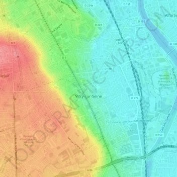
Vitry-sur-Seine topographic map
Interactive map
Click on the map to display elevation.
About this map
Name: Vitry-sur-Seine topographic map, elevation, terrain.
Average elevation: 62 m
Minimum elevation: 28 m
Maximum elevation: 116 m
Other topographic maps
Click on a map to view its topography, its elevation and its terrain.
Arcueil
France > Ile-de-France > Val-de-Marne
Arcueil, L'Haÿ-les-Roses, Val-de-Marne, Ile-de-France, Metropolitan France, 94110, France
Average elevation: 78 m
Chennevières-sur-Marne
France > Ile-de-France > Val-de-Marne
Chennevières-sur-Marne, Créteil, Val-de-Marne, Ile-de-France, Metropolitan France, 94430, France
Average elevation: 76 m
Alfortville
France > Ile-de-France > Val-de-Marne
Alfortville, Créteil, Val-de-Marne, Ile-de-France, Metropolitan France, 94140, France
Average elevation: 39 m
Saint-Maur-des-Fossés
France > Ile-de-France > Val-de-Marne
Saint-Maur-des-Fossés, Nogent-sur-Marne, Val-de-Marne, Ile-de-France, Metropolitan France, France
Average elevation: 42 m
Fontenay-sous-Bois
France > Ile-de-France > Val-de-Marne
Fontenay-sous-Bois, Nogent-sur-Marne, Val-de-Marne, Ile-de-France, Metropolitan France, 94120, France
Average elevation: 76 m
Ormesson-sur-Marne
France > Ile-de-France > Val-de-Marne
Ormesson-sur-Marne, Créteil, Val-de-Marne, Ile-de-France, Metropolitan France, 94490, France
Average elevation: 94 m
Ivry-sur-Seine
France > Ile-de-France > Val-de-Marne
Ivry-sur-Seine, Arrondissement de L'Haÿ-les-Roses, Val-de-Marne, Ile-de-France, Metropolitan France, 94200, France
Average elevation: 49 m
Choisy-le-Roi
France > Ile-de-France > Val-de-Marne
Choisy-le-Roi, Arrondissement de L'Haÿ-les-Roses, Val-de-Marne, Ile-de-France, Metropolitan France, 94600, France
Average elevation: 47 m
Créteil
France > Ile-de-France > Val-de-Marne
Créteil, Val-de-Marne, Ile-de-France, Metropolitan France, 94000, France
Average elevation: 40 m
Valenton
France > Ile-de-France > Val-de-Marne > Valenton > Valenton
Valenton, Arrondissement de L'Haÿ-les-Roses, Val-de-Marne, Ile-de-France, Metropolitan France, 94460, France
Average elevation: 56 m
Nogent-sur-Marne
France > Ile-de-France > Val-de-Marne > Nogent-sur-Marne > Nogent-sur-Marne
Nogent-sur-Marne, Val-de-Marne, Ile-de-France, Metropolitan France, 94130, France
Average elevation: 66 m
Chevilly-Larue
France > Ile-de-France > Val-de-Marne > Chevilly-Larue
Chevilly-Larue, Arrondissement de L'Haÿ-les-Roses, Val-de-Marne, Ile-de-France, Metropolitan France, 94550, France
Average elevation: 89 m
Bry-sur-Marne
France > Ile-de-France > Val-de-Marne > Bry-sur-Marne
Bry-sur-Marne, Nogent-sur-Marne, Val-de-Marne, Ile-de-France, Metropolitan France, 94360, France
Average elevation: 58 m
Villeneuve-Saint-Georges
France > Ile-de-France > Val-de-Marne
Villeneuve-Saint-Georges, L'Haÿ-les-Roses, Val-de-Marne, Ile-de-France, Metropolitan France, 94190, France
Average elevation: 49 m
Orly
France > Ile-de-France > Val-de-Marne
Orly, Arrondissement de L'Haÿ-les-Roses, Val-de-Marne, Ile-de-France, Metropolitan France, 94310, France
Average elevation: 63 m
Cachan
France > Ile-de-France > Val-de-Marne
Cachan, Arrondissement de L'Haÿ-les-Roses, Val-de-Marne, Ile-de-France, Metropolitan France, 94230, France
Average elevation: 79 m
Ablon-sur-Seine
France > Ile-de-France > Val-de-Marne
Ablon-sur-Seine, L'Haÿ-les-Roses, Val-de-Marne, Ile-de-France, Metropolitan France, 94480, France
Average elevation: 46 m
Nogent-sur-Marne
France > Ile-de-France > Val-de-Marne
Nogent-sur-Marne, Val-de-Marne, Ile-de-France, Metropolitan France, 94130, France
Average elevation: 59 m
Vincennes
France > Ile-de-France > Val-de-Marne
Vincennes, Nogent-sur-Marne, Val-de-Marne, Ile-de-France, Metropolitan France, 94300, France
Average elevation: 62 m
Maisons-Alfort
France > Ile-de-France > Val-de-Marne
Maisons-Alfort, Nogent-sur-Marne, Val-de-Marne, Ile-de-France, Metropolitan France, 94700, France
Average elevation: 38 m