
Höhlen topographic map
Interactive map
Click on the map to display elevation.
About this map
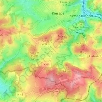
Name: Höhlen topographic map, elevation, terrain.
Average elevation: 415 m
Minimum elevation: 341 m
Maximum elevation: 489 m
Other topographic maps
Click on a map to view its topography, its elevation and its terrain.
Windfuhr
Deutschland > Nordrhein-Westfalen > Märkischer Kreis > Kierspe > Kierspe-Bahnhof > Windfuhr
Windfuhr, Kierspe-Bahnhof, Kierspe, Märkischer Kreis, Nordrhein-Westfalen, 58566, Deutschland
Average elevation: 405 m