
Make a donation
Callicoon topographic map
Click on the map to display elevation.
Make a donation
About this map
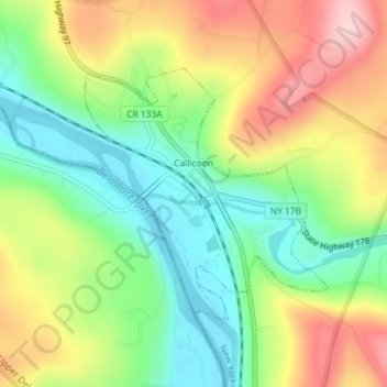
Name: Callicoon topographic map, elevation, terrain.
Average elevation: 311 m
Minimum elevation: 216 m
Maximum elevation: 439 m
Make a donation
Other topographic maps
Click on a map to view its topography, its elevation and its terrain.
Make a donation
Make a donation
Shawangunk Ridge
United States > New York > Sullivan County
The ridge is widest (7.5 miles (12.1 km)) near the northern end and narrow in the middle (1.25 miles (2.01 km)), with a maximum elevation of 2,289 feet (698 m) near Lake Maratanza. The ridge rises above a broad, high plain which stretches to the Hudson River to the east. On the west the low foothills of the…
Average elevation: 256 m
Make a donation
Evens Lake
United States > New York > Sullivan County > Town of Fallsburg > Loch Sheldrake
Average elevation: 443 m
Make a donation
Parkston
United States > New York > Sullivan County > Town of Rockland > Parkston
Average elevation: 567 m
White Sulphur Springs
United States > New York > Sullivan County > Town of Liberty > White Sulphur Springs
Average elevation: 455 m
Make a donation