
Raïon de Zol topographic map
Interactive map
Click on the map to display elevation.
About this map
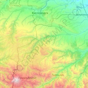
Name: Raïon de Zol topographic map, elevation, terrain.
Average elevation: 1,758 m
Minimum elevation: 478 m
Maximum elevation: 5,630 m
Other topographic maps
Click on a map to view its topography, its elevation and its terrain.
Терскол
Russie > Kabardino-Balkarie > Эльбрусский район > Терскол
Терскол, сельское поселение Эльбрус, Эльбрусский район, Kabardino-Balkarie, District fédéral du Caucase du Nord, 361605, Russie
Average elevation: 2,318 m
Эльбрусский район
Эльбрусский район, Kabardino-Balkarie, District fédéral du Caucase du Nord, Russie
Average elevation: 2,306 m