
Thank you for supporting this site ❤️
Make a donation
Make a donation
Robertson County topographic map
Click on the map to display elevation.
Thank you for supporting this site ❤️
Make a donation
Make a donation
About this map
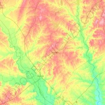
Name: Robertson County topographic map, elevation, terrain.
Location: Robertson County, Texas, United States (30.69592 -96.83128 31.35706 -96.23509)
Average elevation: 115 m
Minimum elevation: 62 m
Maximum elevation: 186 m
Thank you for supporting this site ❤️
Make a donation
Make a donation
Other topographic maps
Click on a map to view its topography, its elevation and its terrain.
Lavon Beach Estates
United States > Texas > Collin County > Lavon Beach Estates
Average elevation: 154 m
Thank you for supporting this site ❤️
Make a donation
Make a donation