
Make a donation
Deception Island topographic map
Click on the map to display elevation.
Make a donation
About this map
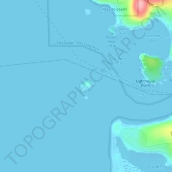
Name: Deception Island topographic map, elevation, terrain.
Location: Deception Island, Island County, Washington, United States (48.40654 -122.67250 48.40865 -122.66859)
Average elevation: 5 m
Minimum elevation: -4 m
Maximum elevation: 121 m
Make a donation
Other topographic maps
Click on a map to view its topography, its elevation and its terrain.
Snoqualmie Pass
United States > Washington > King County
Due to its elevation, Snoqualmie Pass experiences significantly lower temperatures than Seattle, and receives much more precipitation, much of it being snow. Snoqualmie Pass has a humid continental climate (Koppen: Dsb bordering Csb) with cold, very wet and snowy winters, and mild to warm, relatively dry…
Average elevation: 1,048 m
Walla Walla
United States > Washington > Walla Walla County
Walla Walla County features a varied topography characterized by rolling hills, valleys, and river systems. The elevation in the area averages around 940 feet (approximately 287 meters) above sea level, with some areas rising to nearly 1,200 feet. The landscape is shaped by the Walla Walla River, which carves…
Average elevation: 297 m
Make a donation
Make a donation
Make a donation
Make a donation
Make a donation
Make a donation
Make a donation
Make a donation
Make a donation
Lake Chelan
United States > Washington > Chelan County > Chelan
Lake Chelan (/ʃəˈlæn/ shə-LAN) is a narrow, 50.5 mi (81.3 km) long lake in Chelan County, north-central Washington state, U.S. It is an overdeepened lake and resembles a fjord, with an average width of 1.3 mi (2.1 km). Near its upper end, the lake surface lies more than 6,600 ft (2,000 m) below peaks less…
Average elevation: 1,358 m
Make a donation
Bellingham
United States > Washington > Whatcom County > Bellingham
According to the United States Census Bureau, the city has a total area of 28.90 square miles (74.85 km2), of which, 27.08 square miles (70.14 km2) is land and 1.82 square miles (4.71 km2) is water. The lowest elevations are at sea level along the waterfront. Alabama Hill is one of the higher points in the…
Average elevation: 129 m
Make a donation
Grand Coulee Dam
United States > Washington > Okanogan County
After power shortages in the Northwest during the 1960s, it was determined the six remaining planned pumps be pump-generators. When energy demand is high, the pump-generators can generate electricity with water from the Banks Lake feeder canal adjacent to the dam at a higher elevation. By 1973, the…
Average elevation: 423 m
Make a donation
Ellensburg
United States > Washington > Kittitas County > Ellensburg > Ellensburg
Average elevation: 485 m
Make a donation
Wenatchee Confluence State Park
United States > Washington > Chelan County > Sunnyslope
Average elevation: 208 m
Make a donation
Make a donation
Make a donation
Millwood
United States > Washington > Spokane County
The topography of the city is mostly flat as it lies on the floor of the Spokane Valley, though it does slope gently down towards the north. The northern edge of town is defined by the Spokane River, where the terrain promptly drops about 20 feet down to the river bank.
Average elevation: 600 m
Make a donation
Make a donation
Make a donation
Make a donation
Make a donation
East Wenatchee Bench
United States > Washington > Douglas County > East Wenatchee
Average elevation: 296 m
Make a donation
Washtucna
United States > Washington > Adams County
It sits at the head of Washtucna Coulee, a thin but deep valley that runs west to Connell, Washington where it merges with Providence Coulee to form Esquatzel Coulee. Being located on the floor of the coulee, Washtucna is at relatively lower elevation than the terrain that surrounds it. The floor of the coulee…
Average elevation: 351 m
Make a donation
Make a donation
Make a donation