
Make a donation
Westminster topographic map
Click on the map to display elevation.
Make a donation
About this map
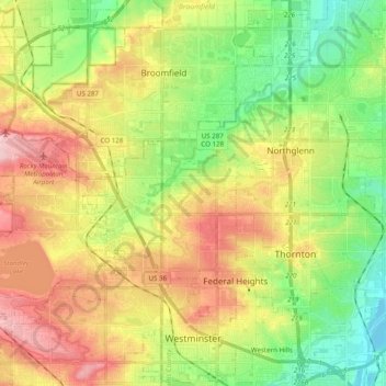
Name: Westminster topographic map, elevation, terrain.
Location: Westminster, Adams County, Colorado, United States (39.81807 -105.16554 39.96854 -104.98768)
Average elevation: 1,630 m
Minimum elevation: 1,548 m
Maximum elevation: 1,737 m
Make a donation
Other topographic maps
Click on a map to view its topography, its elevation and its terrain.
Bennett
United States > Colorado > Adams County
Bennett is located at coordinates 39°45′32″N 104°25′39″W / 39.7589°N 104.4275°W / 39.7589; -104.4275 at an elevation of 5486 at the intersection of State Highways 36 and 79, just north of Interstate 70.
Average elevation: 1,692 m
Make a donation
Bennett
United States > Colorado > Adams County
Bennett is located at coordinates 39°45′32″N 104°25′39″W / 39.7589°N 104.4275°W / 39.7589; -104.4275 at an elevation of 5486 at the intersection of State Highways 36 and 79, just north of Interstate 70.
Average elevation: 1,692 m
Broomfield McKay Bike Park
United States > Colorado > Adams County > Broomfield
Average elevation: 1,601 m
Westminster
United States > Colorado > Adams County > Westminster > Westminster
Average elevation: 1,660 m
Make a donation