
Burleigh County topographic map
Interactive map
Click on the map to display elevation.
About this map
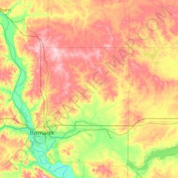
Name: Burleigh County topographic map, elevation, terrain.
Location: Burleigh County, North Dakota, United States of America (46.63163 -100.95960 47.32719 -100.07768)
Average elevation: 572 m
Minimum elevation: 490 m
Maximum elevation: 690 m
Other topographic maps
Click on a map to view its topography, its elevation and its terrain.
Hampden
United States of America > North Dakota > Hampden
Hampden, Ramsey County, North Dakota, 53338, United States of America
Average elevation: 476 m
Flaxton
United States of America > North Dakota > Flaxton
Flaxton, Burke County, North Dakota, United States of America
Average elevation: 589 m
Mountrail County
United States of America > North Dakota
Mountrail County, North Dakota, United States of America
Average elevation: 659 m
Bismarck
United States of America > North Dakota > Bismarck
Bismarck, Burleigh County, North Dakota, United States of America
Average elevation: 523 m