
Make a donation
Tocantins topographic map
Click on the map to display elevation.
Make a donation
Tocantins
The "cerrado" landscape cover 87% of Tocantins and is characterized by extensive savanna formations crossed by gallery forests and stream valleys. Cerrado includes various types of vegetation. Humid fields and "buriti" palm paths are found where the water table is near the surface. Alpine pastures occur at higher altitudes and mesophytic forests on more fertile soils. In the north of Tocantins the cerrado gives place to a zone of transition for the Amazon biome, near Tocantins River.
Make a donation
About this map
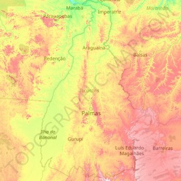
Name: Tocantins topographic map, elevation, terrain.
Location: Tocantins, North Region, Brazil (-13.46700 -50.74127 -5.16945 -45.69926)
Average elevation: 342 m
Minimum elevation: 79 m
Maximum elevation: 1,306 m
Make a donation
Other topographic maps
Click on a map to view its topography, its elevation and its terrain.
Brasília
Brazil > Federal District > Região Integrada de Desenvolvimento do Distrito Federal e Entorno
The city sits at an elevation of 1,000 metres (3,300 ft) and more, high on the Brazilian Highlands in the country's center-western region. Paranoá Lake, a large artificial lake, was built to increase the amount of water available and to maintain the region's humidity. It has a marina, and hosts wakeboarders…
Average elevation: 1,084 m
Região Metropolitana do Recife
Brazil > Pernambuco > Região Metropolitana do Recife > Cabo de Santo Agostinho
Average elevation: 119 m
Make a donation