Geolocate

Central Province topographic map

Interactive map

Click on the map to display elevation.

About this map

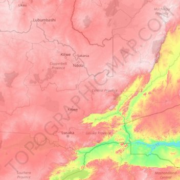
Name: Central Province topographic map, elevation, terrain.

Location: Central Province, Zambia (-15.75348 25.31369 -12.02942 31.43974)

Average elevation: 1,059 m

Minimum elevation: 314 m

Maximum elevation: 1,802 m

Other topographic maps

Click on a map to view its topography, its elevation and its terrain.

Lusaka Province

Zambia

Lusaka Province is bordered along Zimbabwe along Lower Zambezi National Park in the south, Central Province in the north, Southern Province in the southwest and Eastern Province in the north east. The general topography of the province is characterized by uplifted planation surfaces. The general elevation of…

Average elevation: 866 m

Western Province

Zambia

Average elevation: 1,069 m

Livingstone

Zambia > Southern Province

Average elevation: 961 m

Minga Stop

Zambia > Eastern Province > Minga Stop

Average elevation: 912 m

Chinsali

Zambia > Muchinga Province

The geographical coordinates of Chinsali Town are 10°33'08.0"S, 32°04'09.0"E (Latitude:-10.552222; Longitude:32.069167). The town is nestled at an average elevation of 1,383 metres (4,537 ft) above mean sea level.

Average elevation: 1,294 m

Lake Mweru

Zambia > Luapula Province

Average elevation: 1,022 m

Chambeshi

Zambia > Muchinga Province > Chambeshi

Average elevation: 1,192 m

Lake Kariba

Zambia > Southern Province

Average elevation: 854 m