
Cienfuegos topographic map
Interactive map
Click on the map to display elevation.
About this map
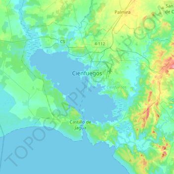
Name: Cienfuegos topographic map, elevation, terrain.
Location: Cienfuegos, Cuba (22.02041 -80.56466 22.22726 -80.27021)
Average elevation: 22 m
Minimum elevation: -1 m
Maximum elevation: 143 m
Other topographic maps
Click on a map to view its topography, its elevation and its terrain.
Parque Alto
Cuba > Cienfuegos > Rodas
Parque Alto, Rodas, Cienfuegos, 59180, Cuba
Average elevation: 27 m