
Thank you for supporting this site ❤️
Make a donation
Make a donation
El Volcán topographic map
Click on the map to display elevation.
Thank you for supporting this site ❤️
Make a donation
Make a donation
About this map
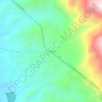
Name: El Volcán topographic map, elevation, terrain.
Location: El Volcán, Comayagua, Honduras (14.41882 -87.59801 14.45882 -87.55801)
Average elevation: 982 m
Minimum elevation: 671 m
Maximum elevation: 1,756 m
Thank you for supporting this site ❤️
Make a donation
Make a donation
Other topographic maps
Click on a map to view its topography, its elevation and its terrain.