
Thank you for supporting this site ❤️
Make a donation
Make a donation
Cubacub topographic map
Click on the map to display elevation.
Thank you for supporting this site ❤️
Make a donation
Make a donation
Cubacub
It is one of the two (the other one being the municipality of Consolacion) local government units located within the mainland Metro Cebu where the elevation of land is less than 100 m (330 ft).
Thank you for supporting this site ❤️
Make a donation
Make a donation
About this map
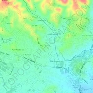
Name: Cubacub topographic map, elevation, terrain.
Location: Cubacub, Mandaue, Central Visayas, Philippines (10.36424 123.93193 10.37771 123.94711)
Average elevation: 35 m
Minimum elevation: 1 m
Maximum elevation: 106 m
Thank you for supporting this site ❤️
Make a donation
Make a donation
Other topographic maps
Click on a map to view its topography, its elevation and its terrain.