
Make a donation
Madhya Pradesh topographic map
Click on the map to display elevation.
Make a donation
Madhya Pradesh
Madhya Pradesh literally means "Central Province", and is located in the geographic heart of India in between the latitude of 21.6°N–26.30°N and longitude of 74°9'E–82°48'E. The state straddles the Narmada River, which runs east and west between the Vindhya and Satpura ranges; these ranges and the Narmada are the traditional boundaries between the north and south of India. The highest point in Madhya Pradesh is Dhupgarh, with an elevation of 1,350 m (4,429 ft).
Make a donation
About this map
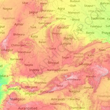
Name: Madhya Pradesh topographic map, elevation, terrain.
Location: Madhya Pradesh, India (21.07081 74.03030 26.86914 82.80942)
Average elevation: 347 m
Minimum elevation: 15 m
Maximum elevation: 1,313 m
Make a donation
Other topographic maps
Click on a map to view its topography, its elevation and its terrain.
Thrissur
Thrissur is the headquarters of Thrissur district, in the centre of the Indian state of Kerala. The city is 75 km north-east of Kochi, 133 km south-west of Coimbatore, 124 km south-east of Kozhikode and 151 km north of Changanacherry. The city is located in a hillock called Thekkinkadu Maidan which is the…
Average elevation: 36 m
Tiruchirappalli
India > Tamil Nadu > Tiruchirappalli
Tiruchirappalli is situated in central south-eastern India, almost at the geographic centre of the state of Tamil Nadu. The Cauvery Delta begins to form 16 kilometres (9.9 mi) west of the city where the river divides into two streams—the Kaveri and the Kollidam—to form the island of Srirangam. By road it…
Average elevation: 83 m
Paonta Sahib
India > Himachal Pradesh > Paonta Sahib
Paonta Sahib is located at 30°26′17″N 77°37′26″E / 30.438°N 77.624°E / 30.438; 77.624. It has an average elevation of 389 metres (1,276 feet). It is on the bank of the river Yamuna, the river being the boundary between the states of Himachal Pradesh and Uttarakhand. It is situated near the…
Average elevation: 443 m
Make a donation
Vagamon
Vagamon, due to its elevation and climate, has a unique ecosystem, leading to the emergence of rich natural vegetation, plant species, shola forests etc. From the early 20th century plantation grew crops like tea and coffee. Vagamon hills are home to less explored flora and fauna. A diversity study conducted…
Average elevation: 866 m
Puducherry
India > Puducherry > Puducherry Taluk
The topography of Pondicherry is the same as that of coastal Tamil Nadu. Pondicherry's average elevation is at sea level and includes a number of sea inlets, referred to locally as "backwaters". Pondicherry experiences extreme coastal erosion as a result of a breakwater constructed in 1989, just to the south…
Average elevation: 10 m
Make a donation
Rudraprayag
India > Uttarakhand > Rudraprayag
Rudraprayag district is located at 30°17′N 78°59′E / 30.28°N 78.98°E / 30.28; 78.98. It has an average elevation of 895 metres (2,936 feet).
Average elevation: 1,140 m
Nalgonda
India > Telangana > Nalgonda mandal
Nalgonda is located at 17°03′00″N 79°16′00″E / 17.050°N 79.2667°E / 17.050; 79.2667. It has an average elevation of 420 metres (1,380 ft).
Average elevation: 219 m
Neyyatinkara
India > Kerala > Neyyattinkara
Neyyattinkara is located at 8°24′N 77°05′E / 8.4°N 77.08°E / 8.4; 77.08. It has an average elevation of 26 metres (85 feet). The town is situated on the Neyyar River side, one of the principal rivers in Trivandrum district. The river flows to the south part of the town. Water Supply for the…
Average elevation: 38 m
Bundi
India > Rajasthan > Bundi Tehsil
The town of Bundi is situated 35 km from Kota and 210 km from Jaipur. It is located at 25°26′N 75°38′E / 25.44°N 75.64°E / 25.44; 75.64 and an average elevation of 268 metres (879 feet). The city lies near a narrow gorge, and is surrounded on three sides by hills of the Aravalli Range. A…
Average elevation: 284 m
Make a donation
Navi Mumbai
India > Maharashtra > Navi Mumbai
Navi Mumbai (Marathi pronunciation: , also known by its former name New Bombay), is a planned city off the west coast of the Indian state of Maharashtra in Konkan division. The city is divided into two parts, North Navi Mumbai and South Navi Mumbai, for the individual development of Panvel Mega City, which…
Average elevation: 30 m
Make a donation
Hodal
Hodal is a town and a municipal council, located, on Palwal Road in Palwal district in the Haryana state of India.It is Part of Braj region. Its language is Braj bhasha & Haryanvi. It is located at 27°53′39″N 77°22′09″E / 27.89417°N 77.36917°E / 27.89417; 77.36917 and has an average…
Average elevation: 190 m
Pavagada
India > Karnataka > Pavagada taluk
Pavagada is located at 14°06′N 77°16′E / 14.1°N 77.27°E / 14.1; 77.27. It has an average elevation of 646 metres (2,119 feet).
Average elevation: 643 m
Make a donation
Chittorgarh
India > Rajasthan > Chittaurgarh Tehsil
Chittorgarh is located at 24°53′N 74°38′E / 24.88°N 74.63°E / 24.88; 74.63. It has an average elevation of 394 metres (1292 ft).Chittorgarh is located in the southern part of the state of Rajasthan, in the northwestern part of India. It is located beside a high hill near the Gambhiri River.…
Average elevation: 442 m
Make a donation
Fatehpur Shekhawati
India > Rajasthan > Fatehpur Tehsil
Fatehpur is located at 27°59′N 74°57′E / 27.98°N 74.95°E / 27.98; 74.95. It has an average elevation of 324 metres (1066 ft). It is home to very rare Jojoba farm.
Average elevation: 327 m
Chikkaballapura
India > Karnataka > Chikkaballapura taluk
The town of Chikkaballapur is approximately 56 km north of Bengaluru (formerly Bangalore) & Kolar city. Chikkaballapur has a high elevation located in the center of the Nandi Hills region. "Panchagiri" is a common descriptor of Chikkaballapur as it is surrounded by 5 picturesque hills among which Nandi Hills…
Average elevation: 929 m
Nakodar
India > Punjab > Nakodar Tahsil
Nakodar is located at 31°08′N 75°28′E / 31.13°N 75.47°E / 31.13; 75.47. It has an average elevation of 223 metres (731 feet). Nakodar lies on Moga-Jalandhar section of National Highway 703 (NH 703).
Average elevation: 231 m
Bikaner
India > Rajasthan > Bikaner Tehsil
Around a century after Rao Bika founded Bikaner, the state's fortunes flourished under the sixth Raja, Rai Singhji, who ruled from 1571 to 1611. During the Mughal Empire's rule in the country, Raja Rai Singh accepted the suzerainty of the Mughals and held a high rank as an army general at the court of the…
Average elevation: 225 m
Make a donation
Chakan
India > Maharashtra > Khed
Shiroli Chandus village, located 6 km north of Chakan, had been identified as the probable site for the proposed Pune International Airport, but due to the protests by the villagers & uneven topography, the site has been shifted to Purandar.
Average elevation: 624 m
Nowshera
India > Jammu and Kashmir > Nowshehra Tehsil
Given its spatial and demographic extent, Nowshera has been given the status of a Sub-District. It is a beautiful place with a number of tourist attractions including the fort of Mangla Devi, holy cave temple of Mangla Mata, Central Gurudwara of Sikhs in Nonial, Qila Darhal and other Dargahs and temples. The…
Average elevation: 668 m
Warangal
India > Telangana > Warangal mandal
Warangal is located at 18°00′N 79°35′E / 18.0°N 79.58°E / 18.0; 79.58. It has an average elevation of 266 metres (873 feet). It is settled in the eastern part of Deccan Plateau made up of granite rocks and hill formations which left the region barren making the cultivation dependent on…
Average elevation: 268 m
Make a donation
Chidambaram
India > Tamil Nadu > Chidambaram
Chidambaram is located at 11°23′N 79°41′E / 11.39°N 79.69°E / 11.39; 79.69. The town is located in Cuddalore district of the South Indian state, Tamil Nadu, 215 km (134 mi) from Chennai. Chidambaram is located close to the shores of Bay of Bengal. The topography is almost plain with forests…
Average elevation: 5 m
Kanchipuram
Kanchipuram is located at 12°59′N 79°43′E / 12.98°N 79.71°E / 12.98; 79.71, 72 km (45 mi) south-west of Chennai on the banks of the Vegavathi River, a tributary of the Palar River. The city covers an area of 11.6 km2 (4.5 sq mi) and has an elevation of 83.2 m (273 ft) above sea level.The land…
Average elevation: 82 m
Make a donation
Make a donation
Sullurpeta
India > Andhra Pradesh > Sullurpeta
Sullurupeta is located about 77 km east of Tirupati, 90 km south of Nellore and about 83 km north of Chennai, Tamilnadu. It is 16 km west of the world-famous ISRO island Sriharikota, where the Indian rockets are launched. The Pulicat lake separates Sullurpeta and Sriharikota. It has an average elevation of 11…
Average elevation: 4 m
Chikhli
India > Gujarat > Chikhli Taluka
Chikhli is located at 20°45′N 73°04′E / 20.75°N 73.07°E / 20.75; 73.07. It has an average elevation of 19 metres (62 ft).
Average elevation: 23 m
Chanderi
India > Madhya Pradesh > Chanderi Tahsil
Chanderi is located at 24°43′N 78°08′E / 24.72°N 78.13°E / 24.72; 78.13. It has an average elevation of 456 metres (1496 feet).
Average elevation: 440 m
Make a donation
Jowai
India > Meghalaya > Thadlaskein
Jowai (IPA: ʤəʊˈwaɪ) is the headquarters of the West Jaintia Hills district of the state of Meghalaya, India, and is home to the Pnar, a sub-tribe of the Khasi people. It is located on a plateau surrounded on three sides by the Myntdu river bordering Bangladesh to the south (about 50 km from the…
Average elevation: 1,332 m
Make a donation
Balaghat
India > Madhya Pradesh > Balagat Tahsil
Balaghat is located at 21°48′N 80°11′E / 21.800°N 80.183°E / 21.800; 80.183. It has an average elevation of 288 metres (944 feet).
Average elevation: 304 m
Sehore
India > Madhya Pradesh > Sehore Nagar Tahsil
Sehore is 37 km from the state capital, Bhopal, towards the south-west and on the Bhopal - Indore highway. Its height from mean sea level is between 1500 ft. and 2000 ft. Sehore is situated on the Western Railway line from Bhopal to Ratlam. It is surrounded by 7 districts: Bhopal, Raisen, Harda, Hoshangabad,…
Average elevation: 501 m
Make a donation
Holalkere
India > Karnataka > Holalkere taluk
Holalkere is located at 14°02′N 76°11′E / 14.03°N 76.18°E / 14.03; 76.18. It has an average elevation of 711 metres (2332 feet).
Average elevation: 715 m
Itanagar
India > Arunachal Pradesh > Itanagar EAC
Itanagar is located at 27°06′N 93°37′E / 27.1°N 93.62°E / 27.1; 93.62. It has an average elevation of 320 metres.
Average elevation: 539 m
Make a donation
Arasikere
India > Karnataka > Arasikere taluku
Arsikere is located at 13°18′52″N 76°15′25″E / 13.31444°N 76.25694°E / 13.31444; 76.25694. It has an average elevation of 812 metres (2,664 feet).
Average elevation: 835 m
Patiala
India > Punjab > Patiala Tahsil
Patiala is located at 30°19′N 76°24′E / 30.32°N 76.40°E / 30.32; 76.40. It has an average elevation of 250 metres (820 feet). During the short existence of PEPSU, Patiala served as its capital city.
Average elevation: 255 m
Make a donation
Make a donation
Salur
India > Andhra Pradesh > Salur
Salur is on the banks of River Vegavathi at 18°32′00″N 83°13′00″E / 18.5333°N 83.2167°E / 18.5333; 83.2167. It has an average elevation of 118 metres (387 ft). It is bounded by Makkuva, Bobbili, Ramabhadrapuram and Pachipenta mandals of Andhra Pradesh state. Salur is surrounded with green…
Average elevation: 163 m
Make a donation
Alibag
India > Maharashtra > Alibag Taluka
Alibag is located about 120 km south of Mumbai, at 18°38′29″N 72°52′20″E / 18.64139°N 72.87222°E / 18.64139; 72.87222. The average elevation is 0 metres (0 feet).The District Government offices are located along the sea coast road. Alibag is the center place of Raigad District.
Average elevation: 12 m
Make a donation
Shrigonda
India > Maharashtra > Shrigonda
Shrigonda is a municipal council in Ahilyanagar - Ahmednagar district in the Indian state of Maharashtra. Shrigonda is located at 18°36′58″N 74°41′53″E / 18.616°N 74.698°E / 18.616; 74.698. It has an average elevation of 561 metres (1840 feet). As of the 2001 Indian census, Shrigonda had a…
Average elevation: 560 m
Make a donation
Make a donation
Dharapuram
India > Tamil Nadu > Dharapuram
Dharapuram is located at 10°44′N 77°31′E / 10.73°N 77.52°E / 10.73; 77.52. Dharapuram town is situated along of the bank of Amaravathi River which flows from the south to north. Uppar River and dam, Nallathankal River and dam, Palar join the river Amaravathi. It has an average elevation of 245…
Average elevation: 252 m
Make a donation
Beawar
India > Rajasthan > Beawar Tehsil
Beawar is located at 26°06′N 74°19′E / 26.1°N 74.32°E / 26.1; 74.32. It has an average elevation of 439 metres (1,440 ft).
Average elevation: 455 m
Make a donation
Tiruppur
India > Tamil Nadu > Tiruppur South
Tiruppur is located at 11°06′27″N 77°20′23″E / 11.1075°N 77.3398°E / 11.1075; 77.3398 on the banks of the Noyyal River. It has an average elevation of 295 metres (967 feet) and covers an area of 159.6 km2 (61.6 sq mi).
Average elevation: 334 m
Ranebennur
India > Karnataka > Ranebennuru taluk
Ranebennuru is at the geographical center of Karnataka. 14°37′N 75°37′E / 14.62°N 75.62°E / 14.62; 75.62. It has an average elevation of 605 metres (1,985 ft). One of Karnataka's most important rivers – the Tungabhadra – flows along the southern border of Ranebennur taluk. Another river,…
Average elevation: 574 m
Make a donation
Pratapgarh
India > Rajasthan > Pratapgarh Tehsil
Pratapgarh District is a newly constituted district in Rajasthan state. it came into existence on 26 January 2008, as the 33rd district of Rajasthan. Pratapgarh is located at 24.03° N 74.78° E. It has an average elevation of 491 metres (1610 feet). It is said to be the second highest place in Rajasthan after…
Average elevation: 503 m
Kotdwar
India > Uttarakhand > Kotdwara
Kotdwar lies on the western margin of the Himalayas, at an altitude of 454 m (1,490 ft) above sea level.
Average elevation: 471 m
Make a donation
Huzurabad
India > Telangana > Huzurabad mandal
Huzurabad is at 18°12′N 79°25′E / 18.20°N 79.42°E / 18.20; 79.42. It has an average elevation of 271 metres (889 ft).
Average elevation: 270 m
Make a donation