La Antigua topographic map
Interactive map
Click on the map to display elevation.
About this map
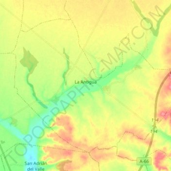
Name: La Antigua topographic map, elevation, terrain.
Location: La Antigua, León, Castile and León, 24796, Spain (42.13826 -5.74814 42.21548 -5.61539)
Average elevation: 766 m
Minimum elevation: 730 m
Maximum elevation: 803 m
Other topographic maps
Click on a map to view its topography, its elevation and its terrain.
Valladolid
Spain > Castile and León > Valladolid
Valladolid is located at roughly 735 metres above sea level, at the centre of the Meseta Norte, the plateau drained by the Douro river basin covering a major part of the Northwest of the Iberian Peninsula. The primitive urban core was built ex novo in the 11th century on a small elevation near the confluence…
Average elevation: 768 m
Salamanca
The city is located at an altitude of 800 meters above sea level. The altitude of the municipality varies from 911 meters (Los Montalvos), in the southwest, and 763 meters in the last stretch in the municipality of the Tormes river.
Average elevation: 812 m
Burgos
Spain > Castile and León > Burgos
At an elevation of 856 metres (2,808 ft), the city of Burgos lies in the transition zone between a Warm-summer Mediterranean climate (Köppen Csb) and an Oceanic climate (Köppen Cfb), with some continental influence resulting from its distance from the sea and higher altitude. Burgos' climate features chilly…
Average elevation: 907 m