
Thank you for supporting this site ❤️
Make a donation
Make a donation
Bayho topographic map
Click on the map to display elevation.
Thank you for supporting this site ❤️
Make a donation
Make a donation
About this map
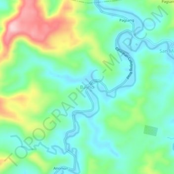
Name: Bayho topographic map, elevation, terrain.
Location: Bayho, Northern Samar, Eastern Visayas, 6403, Philippines (12.31029 124.62684 12.35029 124.66684)
Average elevation: 82 m
Minimum elevation: 13 m
Maximum elevation: 245 m
Thank you for supporting this site ❤️
Make a donation
Make a donation
Other topographic maps
Click on a map to view its topography, its elevation and its terrain.