
Santa Fe topographic map
Click on the map to display elevation.
Santa Fe
Santa Fe (/ˌsæntə ˈfeɪ, ˈsæntə feɪ/ SAN-tə FAY, - fay; Spanish: [santaˈfe]) is the capital of the U.S. state of New Mexico, and the county seat of Santa Fe County. With over 89,000 residents, Santa Fe is the fourth-most populous city in the state, and part of the Albuquerque–Santa Fe–Los Alamos combined statistical area, which had a population of 1,162,523 in 2020. Situated at the foothills of the Sangre de Cristo Mountains, the city is at the highest altitude of any U.S. state capital, with an elevation of 6,998 feet (2,133 m).
About this map
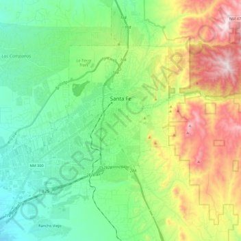
Name: Santa Fe topographic map, elevation, terrain.
Location: Santa Fe, Santa Fe County, New Mexico, United States (35.58804 -106.11216 35.75462 -105.89418)
Average elevation: 2,221 m
Minimum elevation: 1,915 m
Maximum elevation: 2,862 m
Other topographic maps
Click on a map to view its topography, its elevation and its terrain.