
Vallcebre topographic map
Interactive map
Click on the map to display elevation.
About this map
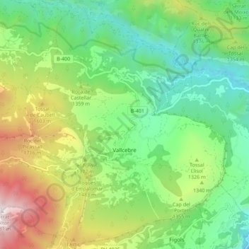
Name: Vallcebre topographic map, elevation, terrain.
Location: Vallcebre, Berguedà, Barcelona, Catalonië, 08699, Spanje (42.17948 1.76838 42.24050 1.85322)
Average elevation: 1,225 m
Minimum elevation: 697 m
Maximum elevation: 2,244 m
Other topographic maps
Click on a map to view its topography, its elevation and its terrain.
Parc Natural del Cadí-Moixeró
Spanje > Catalonië > Berguedà > Gisclareny
Parc Natural del Cadí-Moixeró, Gisclareny, Berguedà, Barcelona, Catalonië, Spanje
Average elevation: 1,439 m
Collada Fonda
Spanje > Catalonië > Berguedà > Castell de l'Areny
Collada Fonda, Castell de l'Areny, Berguedà, Barcelona, Catalonië, 08604, Spanje
Average elevation: 1,483 m
L'Espunyola
Spanje > Catalonië > Berguedà > l'Espunyola > L'Espunyola
L'Espunyola, l'Espunyola, Berguedà, Barcelona, Catalonië, 08614, Spanje
Average elevation: 845 m