
Thank you for supporting this site ❤️
Make a donation
Make a donation
Kebnekaise topographic map
Click on the map to display elevation.
Thank you for supporting this site ❤️
Make a donation
Make a donation
About this map
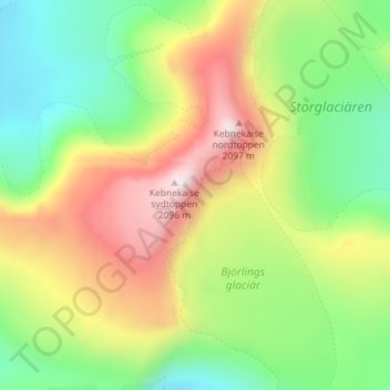
Name: Kebnekaise topographic map, elevation, terrain.
Location: Kebnekaise, Kiruna kommun, Norrbotten County, Sweden (67.89072 18.51375 67.90904 18.52923)
Average elevation: 1,658 m
Minimum elevation: 1,344 m
Maximum elevation: 2,116 m
Thank you for supporting this site ❤️
Make a donation
Make a donation
Other topographic maps
Click on a map to view its topography, its elevation and its terrain.