
Alençon topographic map
Interactive map
Click on the map to display elevation.
About this map
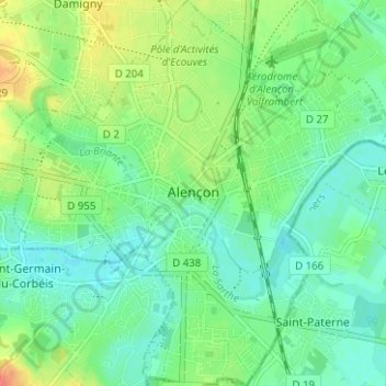
Name: Alençon topographic map, elevation, terrain.
Location: Alençon, Orne, Normandie, France métropolitaine, 61000, France (48.41031 0.06183 48.45183 0.12276)
Average elevation: 142 m
Minimum elevation: 127 m
Maximum elevation: 170 m
La superficie de la commune est de 1 068 hectares ; son altitude varie de 127 à 152 mètres.
Other topographic maps
Click on a map to view its topography, its elevation and its terrain.
Moutiers-au-Perche
Moutiers-au-Perche, Mortagne-au-Perche, Orne, Normandie, France métropolitaine, 61110, France
Average elevation: 199 m
Larchamp
France > Normandie > Orne > Tinchebray-Bocage
Larchamp, Tinchebray-Bocage, Argentan, Orne, Normandie, France métropolitaine, 61800, France
Average elevation: 254 m
La Lande-Patry
France > Normandie > Orne > La Lande-Patry
La Lande-Patry, Argentan, Orne, Normandie, France métropolitaine, 61100, France
Average elevation: 200 m
La Perrière
France > Normandie > Orne > Belforêt-en-Perche
La Perrière, Belforêt-en-Perche, Mortagne-au-Perche, Orne, Normandie, France métropolitaine, 61360, France
Average elevation: 174 m
Lonlay-l'Abbaye
Lonlay-l'Abbaye, Argentan, Orne, Normandie, France métropolitaine, 61700, France
Average elevation: 214 m