
Make a donation
Grande-Rivière topographic map
Click on the map to display elevation.
Make a donation
About this map
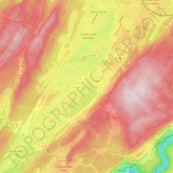
Name: Grande-Rivière topographic map, elevation, terrain.
Average elevation: 947 m
Minimum elevation: 605 m
Maximum elevation: 1,154 m
Make a donation
Other topographic maps
Click on a map to view its topography, its elevation and its terrain.
Lac de l'Abbaye
France > Bourgogne-Franche-Comté > Jura > Grande-Rivière-Château > Grande-Rivière
Le lac de l'Abbaye est un lac glaciaire du Jura français situé à près de 900 mètres d’altitude, à la limite du Haut-Jura, à 7 kilomètres au sud de Saint-Laurent-en-Grandvaux, sur la commune de Grande-Rivière (dénomination particulière à l’endroit puisqu’il n'y a pas de rivière à proximité).
Average elevation: 923 m
Château-des-Prés
France > Bourgogne-Franche-Comté > Jura > Grande-Rivière-Château
Average elevation: 897 m
Les Chauvins
France > Bourgogne-Franche-Comté > Jura > Grande-Rivière-Château
Average elevation: 925 m