
Thank you for supporting this site ❤️
Make a donation
Make a donation
Halle (Saale) topographic map
Click on the map to display elevation.
Thank you for supporting this site ❤️
Make a donation
Make a donation
About this map
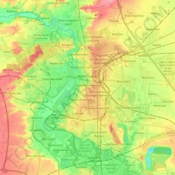
Name: Halle (Saale) topographic map, elevation, terrain.
Location: Halle (Saale), Saxony-Anhalt, Germany (51.40210 11.85525 51.54351 12.08922)
Average elevation: 100 m
Minimum elevation: 59 m
Maximum elevation: 144 m
Thank you for supporting this site ❤️
Make a donation
Make a donation
Other topographic maps
Click on a map to view its topography, its elevation and its terrain.
Dessau
Germany > Saxony-Anhalt > Dessau-Roßlau
Dessau is situated on a floodplain where the Mulde flows into the Elbe. This causes yearly floods. The worst flood took place in the year 2002, when the Waldersee district was nearly completely flooded. The south of Dessau touches a well-wooded area called Mosigkauer Heide. The highest elevation is a 110 m…
Average elevation: 62 m