
Thank you for supporting this site ❤️
Make a donation
Make a donation
Archemerberg topographic map
Click on the map to display elevation.
Thank you for supporting this site ❤️
Make a donation
Make a donation
Archemerberg
Topografisch kaartbeeld van de Archemerberg, december 2015. Klik voor een vergroting.
Thank you for supporting this site ❤️
Make a donation
Make a donation
About this map
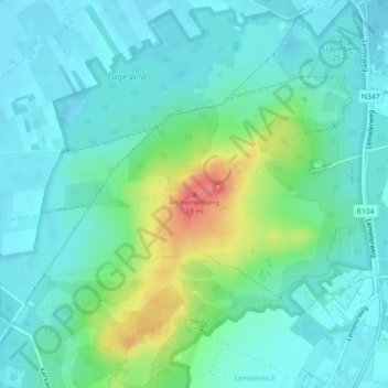
Name: Archemerberg topographic map, elevation, terrain.
Average elevation: 22 m
Minimum elevation: 5 m
Maximum elevation: 75 m
Thank you for supporting this site ❤️
Make a donation
Make a donation
Other topographic maps
Click on a map to view its topography, its elevation and its terrain.