
Make a donation
Sucumbíos topographic map
Click on the map to display elevation.
Make a donation
Sucumbíos
The western area of the province belongs to the Eastern Andes Mountains, where most rivers in the province have their sources. The most important elevation in the province is the Reventador, an active volcano. The eastern portion of the province is part of the Amazon Basin, with high temperatures.
Make a donation
About this map
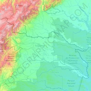
Name: Sucumbíos topographic map, elevation, terrain.
Location: Sucumbíos, Ecuador (-0.65617 -77.97953 0.66245 -75.22331)
Average elevation: 711 m
Minimum elevation: 162 m
Maximum elevation: 4,569 m
Make a donation
Other topographic maps
Click on a map to view its topography, its elevation and its terrain.
Quito
Ecuador > Pichincha > Quito Canton
Quito's elevation of 2,850 m (9,350 ft) makes it either the highest or the second highest capital city in the world. This varied standing is because Bolivia is a country with multiple capitals; if La Paz is considered the Bolivian national capital, it tops the list of highest capitals, but if Sucre is…
Average elevation: 2,930 m
Make a donation