
Make a donation
Zulia State topographic map
Click on the map to display elevation.
Make a donation
Zulia State
These orogenic processes made the Perijá mountain range suffer a less intense uplift than the Andes and, therefore, its structural pattern and relief are more moderate. Likewise, the Ziruma mountain range develops towards the southeast, considered as a pre-mountain range system of relatively lower altitudes, where only tertiary rocks emerge. . According to the most recent classification, the state of Zulia presents three basic physical-natural units: the natural region of the Perijá mountain range; the natural region of the Corian sierras and the natural region formed by the depression of the Maracaibo lake and the coastal plains of the gulf of Venezuela.
Make a donation
About this map
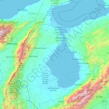
Name: Zulia State topographic map, elevation, terrain.
Location: Zulia State, Venezuela (8.36347 -73.35296 11.85058 -70.67004)
Average elevation: 434 m
Minimum elevation: -6 m
Maximum elevation: 5,125 m
Make a donation
Other topographic maps
Click on a map to view its topography, its elevation and its terrain.
Make a donation
Valencia
Venezuela > Carabobo State > Municipio Valencia
The elevation of the city is 520 metres (1,710 feet).
Average elevation: 600 m
Make a donation