
Buenaventura topographic map
Interactive map
Click on the map to display elevation.
About this map
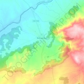
Name: Buenaventura topographic map, elevation, terrain.
Location: Buenaventura, Castile-La Mancha, 45634, Spain (40.14069 -4.92468 40.20519 -4.82349)
Average elevation: 517 m
Minimum elevation: 385 m
Maximum elevation: 780 m
Other topographic maps
Click on a map to view its topography, its elevation and its terrain.
Cuenca
The climate of Cuenca is the typical hot-summer Mediterranean climate of Spain's "Meseta" (inner plateau). Winters are relatively cold, but summers are quite hot during the day with occasional cool nights. Spring and autumn seasons are short, with pleasant temperatures during the day but with rather cold…
Average elevation: 1,124 m