
Thank you for supporting this site ❤️
Make a donation
Make a donation
Harpers Ferry topographic map
Click on the map to display elevation.
Thank you for supporting this site ❤️
Make a donation
Make a donation
Harpers Ferry
The town was "easy to seize, and hard to hold", because of its topography: surrounded on three sides by high ground – Bolivar Heights to the west, Loudoun Heights to the south, and Maryland Heights to the east – and surrounded by the Potomac and Shenandoah Rivers, anyone who controlled the heights controlled the city.
Thank you for supporting this site ❤️
Make a donation
Make a donation
About this map
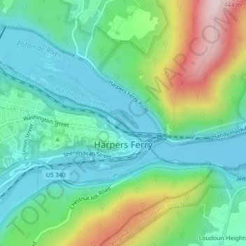
Name: Harpers Ferry topographic map, elevation, terrain.
Average elevation: 174 m
Minimum elevation: 71 m
Maximum elevation: 421 m
Thank you for supporting this site ❤️
Make a donation
Make a donation
Other topographic maps
Click on a map to view its topography, its elevation and its terrain.