
Oxbüll topographic map
Interactive map
Click on the map to display elevation.
About this map
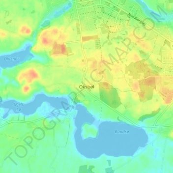
Name: Oxbüll topographic map, elevation, terrain.
Location: Oxbüll, Kommune Sonderburg, Region Süddänemark, 6430, Dänemark (55.01473 9.73309 55.05473 9.77309)
Average elevation: 15 m
Minimum elevation: -9 m
Maximum elevation: 39 m
Other topographic maps
Click on a map to view its topography, its elevation and its terrain.
Broballig
Dänemark > Region Süddänemark > Oxbüll > Broballig
Broballig, Oxbüll, Kommune Sonderburg, Region Süddänemark, 6430, Dänemark
Average elevation: 12 m