
Thank you for supporting this site ❤️
Make a donation
Make a donation
Mambagaton topographic map
Click on the map to display elevation.
Thank you for supporting this site ❤️
Make a donation
Make a donation
About this map
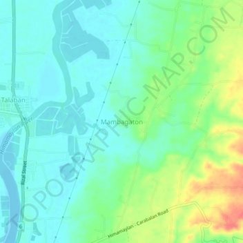
Name: Mambagaton topographic map, elevation, terrain.
Average elevation: 17 m
Minimum elevation: -2 m
Maximum elevation: 58 m
Thank you for supporting this site ❤️
Make a donation
Make a donation
Other topographic maps
Click on a map to view its topography, its elevation and its terrain.
Himamaylan City Public Plaza
Philippines > Negros Occidental > Himamaylan > Barangay Ⅲ
Average elevation: 5 m