
Make a donation
Burg topographic map
Click on the map to display elevation.
Make a donation
About this map
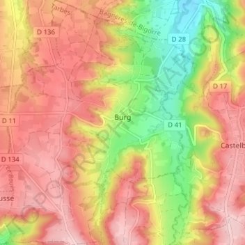
Name: Burg topographic map, elevation, terrain.
Average elevation: 461 m
Minimum elevation: 339 m
Maximum elevation: 546 m
Make a donation
Other topographic maps
Click on a map to view its topography, its elevation and its terrain.
Hôtellerie du Cirque
France > Occitania > Hautes Pyrenees > Gavarnie-Gèdre > Gavarnie
Average elevation: 1,989 m
Make a donation
Cirque de Gavarnie
France > Occitania > Hautes Pyrenees > Gavarnie-Gèdre > Gavarnie
Average elevation: 2,364 m
Lac de Gaube
France > Occitania > Hautes Pyrenees > Cauterets
The lake is situated in an altitude of 1725 m, an egg-shaped form stretching itself along a north–south axis in the valley of Gaube. This steep-sided valley is located at the foot of the Vignemale (3298M). The lake is surrounded by the peak Mayouret (2688 m) to the east, the big Peak of the Paloumères (2720…
Average elevation: 2,079 m
Make a donation
Vue sur Cascades et Pont d'Espagne
France > Occitania > Hautes Pyrenees > Cauterets
Average elevation: 1,827 m
Pierrefitte-Nestalas
France > Occitania > Hautes Pyrenees > Pierrefitte-Nestalas > Pierrefitte-Nestalas
Average elevation: 712 m
Make a donation
Cirque de Gavarnie
France > Occitania > Hautes Pyrenees > Gavarnie-Gèdre > Gavarnie
Average elevation: 2,364 m
Make a donation
Make a donation