
Thank you for supporting this site ❤️
Make a donation
Make a donation
Tasman topographic map
Click on the map to display elevation.
Thank you for supporting this site ❤️
Make a donation
Make a donation
About this map
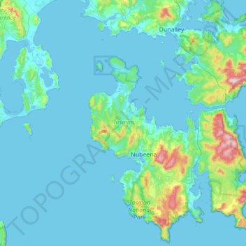
Name: Tasman topographic map, elevation, terrain.
Location: Tasman, Tasmania, Australia (-43.24652 147.61843 -42.84209 148.05513)
Average elevation: 53 m
Minimum elevation: -2 m
Maximum elevation: 576 m
Thank you for supporting this site ❤️
Make a donation
Make a donation
Other topographic maps
Click on a map to view its topography, its elevation and its terrain.
Thank you for supporting this site ❤️
Make a donation
Make a donation
Thank you for supporting this site ❤️
Make a donation
Make a donation
Thank you for supporting this site ❤️
Make a donation
Make a donation