
Ginoza topographic map
Interactive map
Click on the map to display elevation.
About this map
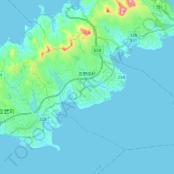
Name: Ginoza topographic map, elevation, terrain.
Location: Ginoza, Kunigami, Okinawa Prefecture, Japan (26.43837 127.92711 26.52983 128.06758)
Average elevation: 32 m
Minimum elevation: 0 m
Maximum elevation: 320 m
Other topographic maps
Click on a map to view its topography, its elevation and its terrain.