
Thank you for supporting this site ❤️
Make a donation
Make a donation
Tyniec topographic map
Click on the map to display elevation.
Thank you for supporting this site ❤️
Make a donation
Make a donation
About this map
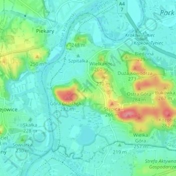
Name: Tyniec topographic map, elevation, terrain.
Location: Tyniec, Dębniki, Krakow, Lesser Poland Voivodeship, Poland (49.99196 19.79224 50.02657 19.85553)
Average elevation: 219 m
Minimum elevation: 200 m
Maximum elevation: 285 m
Thank you for supporting this site ❤️
Make a donation
Make a donation
Other topographic maps
Click on a map to view its topography, its elevation and its terrain.