
Thank you for supporting this site ❤️
Make a donation
Make a donation
Bayhaven topographic map
Click on the map to display elevation.
Thank you for supporting this site ❤️
Make a donation
Make a donation
About this map
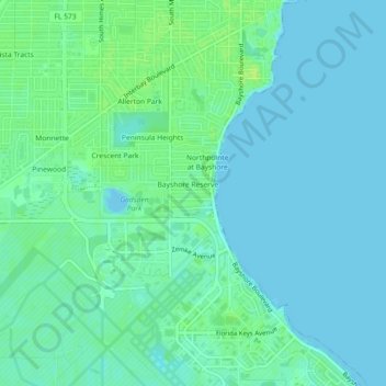
Name: Bayhaven topographic map, elevation, terrain.
Average elevation: 5 m
Minimum elevation: -3 m
Maximum elevation: 13 m
Thank you for supporting this site ❤️
Make a donation
Make a donation
Other topographic maps
Click on a map to view its topography, its elevation and its terrain.
City of Tampa Waterworks Dam
United States > Florida > Hillsborough County > Tampa > Altos Verdes
Average elevation: 13 m
Thank you for supporting this site ❤️
Make a donation
Make a donation