
Thank you for supporting this site ❤️
Make a donation
Make a donation
Hayes topographic map
Click on the map to display elevation.
Thank you for supporting this site ❤️
Make a donation
Make a donation
About this map
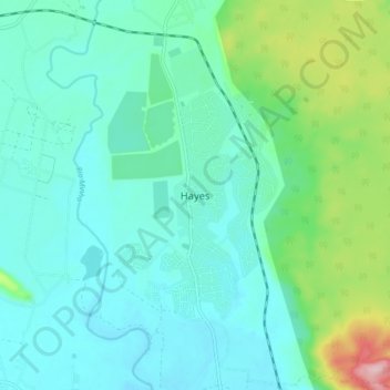
Name: Hayes topographic map, elevation, terrain.
Location: Hayes, Clarendon, Middlesex County, Jamaica (17.83511 -77.28007 17.91511 -77.20007)
Average elevation: 56 m
Minimum elevation: 10 m
Maximum elevation: 235 m
Thank you for supporting this site ❤️
Make a donation
Make a donation