
Thank you for supporting this site ❤️
Make a donation
Make a donation
Swampscott topographic map
Click on the map to display elevation.
Thank you for supporting this site ❤️
Make a donation
Make a donation
About this map
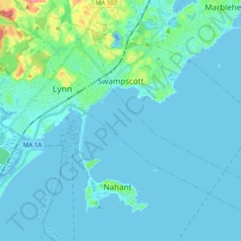
Name: Swampscott topographic map, elevation, terrain.
Average elevation: 8 m
Minimum elevation: -26 m
Maximum elevation: 79 m
Thank you for supporting this site ❤️
Make a donation
Make a donation
Other topographic maps
Click on a map to view its topography, its elevation and its terrain.
Swampscott
United States > Massachusetts > Essex County > Swampscott > Swampscott
Average elevation: 12 m