
Great Misery Island topographic map
Interactive map
Click on the map to display elevation.
About this map
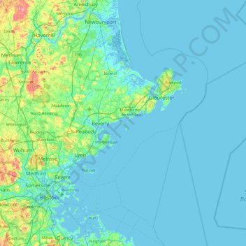
Name: Great Misery Island topographic map, elevation, terrain.
Average elevation: 13 m
Minimum elevation: -4 m
Maximum elevation: 128 m
Other topographic maps
Click on a map to view its topography, its elevation and its terrain.
Salem
United States > Massachusetts > Essex County > Salem
Salem, Essex County, Massachusetts, 01970-3980, United States
Average elevation: 16 m
South Salem
United States > Massachusetts > Essex County > Salem > South Salem
South Salem, Salem, Essex County, Massachusetts, 01970, United States
Average elevation: 11 m