
Make a donation
Malton topographic map
Click on the map to display elevation.
Make a donation
Malton
As with the rest of the British Isles and Yorkshire, Malton possesses a maritime climate with cool summers and mild winters. The nearest Met Office weather station for which records are available is High Mowthorpe, about 6 miles (10 km) east of the town centre. Due to its lower elevation, the town centre is likely to be marginally warmer than High Mowthorpe throughout the year.
Make a donation
About this map
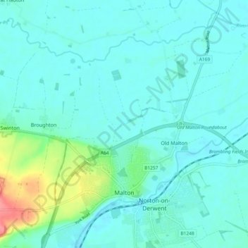
Name: Malton topographic map, elevation, terrain.
Location: Malton, North Yorkshire, England, United Kingdom (54.12565 -0.82388 54.17406 -0.73200)
Average elevation: 28 m
Minimum elevation: 15 m
Maximum elevation: 91 m
Make a donation
Other topographic maps
Click on a map to view its topography, its elevation and its terrain.
Make a donation
Make a donation
Make a donation
Make a donation
Thornydale Laithe
United Kingdom > England > North Yorkshire > Craven > Calton
Average elevation: 179 m
Make a donation
Make a donation
Milby Cut
United Kingdom > England > North Yorkshire > Harrogate > Aldborough > Milby
Average elevation: 20 m