
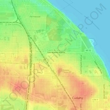
Saint Francis topographic map
Interactive map
Click on the map to display elevation.
About this map
Name: Saint Francis topographic map, elevation, terrain.
Average elevation: 201 m
Minimum elevation: 175 m
Maximum elevation: 224 m
Other topographic maps
Click on a map to view its topography, its elevation and its terrain.
Milwaukee
United States > Wisconsin > Milwaukee County
Milwaukee, Milwaukee County, Wisconsin, United States
Average elevation: 205 m
Fox Point
United States > Wisconsin > Milwaukee County
Fox Point, Milwaukee County, Wisconsin, 53217, United States
Average elevation: 198 m
Greenfield
United States > Wisconsin > Milwaukee County
Greenfield, Milwaukee County, Wisconsin, United States
Average elevation: 234 m
River Hills
United States > Wisconsin > Milwaukee County
River Hills, Milwaukee County, Wisconsin, United States
Average elevation: 209 m
Lakeshore State Park
United States > Wisconsin > Milwaukee County > Milwaukee
Lakeshore State Park, Historic Third Ward, Milwaukee, Milwaukee County, Wisconsin, United States
Average elevation: 180 m
Oak Creek
United States > Wisconsin > Milwaukee County
Oak Creek, Milwaukee County, Wisconsin, 53154, United States
Average elevation: 199 m
Greendale
United States > Wisconsin > Milwaukee County
Greendale, Milwaukee County, Wisconsin, 53129, United States
Average elevation: 232 m
West Allis
United States > Wisconsin > Milwaukee County
West Allis, Milwaukee County, Wisconsin, United States
Average elevation: 224 m
South Milwaukee
United States > Wisconsin > Milwaukee County
South Milwaukee, Milwaukee County, Wisconsin, 53172, United States
Average elevation: 199 m
Shorewood
United States > Wisconsin > Milwaukee County
Shorewood, Milwaukee County, Wisconsin, 53211, United States
Average elevation: 200 m
Milwaukee
United States > Wisconsin > Milwaukee County > Milwaukee
Milwaukee, Milwaukee County, Wisconsin, 53233-2620, United States
Average elevation: 207 m
Wauwatosa
United States > Wisconsin > Milwaukee County
Wauwatosa, Milwaukee County, Wisconsin, United States
Average elevation: 220 m
Cudahy
United States > Wisconsin > Milwaukee County
Cudahy, Milwaukee County, Wisconsin, 53110, United States
Average elevation: 206 m
Noyes Park Creek
United States > Wisconsin > Milwaukee County > Milwaukee
Noyes Park Creek, Menomonee River Hills, Milwaukee, Milwaukee County, Wisconsin, 53224, United States
Average elevation: 227 m
Glendale
United States > Wisconsin > Milwaukee County
Glendale, Milwaukee County, Wisconsin, United States
Average elevation: 203 m
Hales Corners
United States > Wisconsin > Milwaukee County
Hales Corners, Milwaukee County, Wisconsin, 53130, United States
Average elevation: 242 m
Franklin
United States > Wisconsin > Milwaukee County
Franklin, Milwaukee County, Wisconsin, 53132, United States
Average elevation: 234 m
Whitefish Bay
United States > Wisconsin > Milwaukee County
Whitefish Bay, Milwaukee County, Wisconsin, United States
Average elevation: 190 m