
Thank you for supporting this site ❤️
Make a donation
Make a donation
Rayville topographic map
Click on the map to display elevation.
Thank you for supporting this site ❤️
Make a donation
Make a donation
About this map
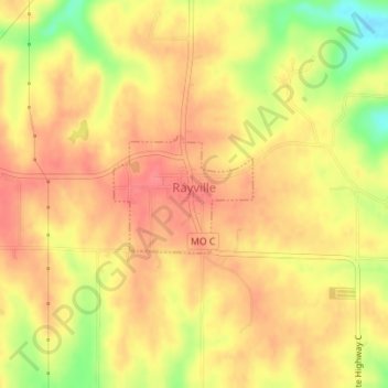
Name: Rayville topographic map, elevation, terrain.
Location: Rayville, Ray County, Missouri, United States (39.34373 -94.07026 39.35193 -94.05770)
Average elevation: 285 m
Minimum elevation: 238 m
Maximum elevation: 308 m
Thank you for supporting this site ❤️
Make a donation
Make a donation
Other topographic maps
Click on a map to view its topography, its elevation and its terrain.