
Thank you for supporting this site ❤️
Make a donation
Make a donation
Mashuru topographic map
Click on the map to display elevation.
Thank you for supporting this site ❤️
Make a donation
Make a donation
About this map
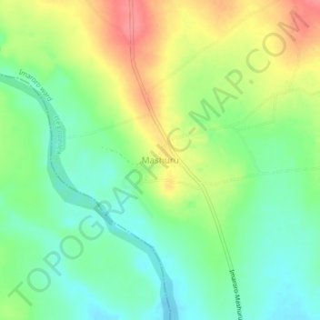
Name: Mashuru topographic map, elevation, terrain.
Location: Mashuru, Imaroro ward, Kajiado East, Rift Valley, Kenya (-2.12150 37.10836 -2.08150 37.14836)
Average elevation: 1,343 m
Minimum elevation: 1,313 m
Maximum elevation: 1,386 m
Thank you for supporting this site ❤️
Make a donation
Make a donation