
Thank you for supporting this site ❤️
Make a donation
Make a donation
Brunswick topographic map
Click on the map to display elevation.
Thank you for supporting this site ❤️
Make a donation
Make a donation
About this map
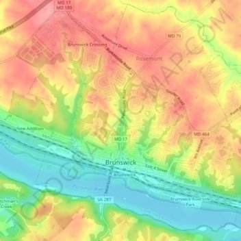
Name: Brunswick topographic map, elevation, terrain.
Location: Brunswick, Frederick County, Maryland, United States (39.30245 -77.65068 39.33683 -77.60239)
Average elevation: 118 m
Minimum elevation: 64 m
Maximum elevation: 163 m
Thank you for supporting this site ❤️
Make a donation
Make a donation