Geolocate

York County topographic map

Interactive map

Click on the map to display elevation.

About this map

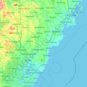
Name: York County topographic map, elevation, terrain.

Location: York County, Maine, United States (42.92222 -70.98912 43.81428 -70.22209)

Average elevation: 72 m

Minimum elevation: -6 m

Maximum elevation: 757 m

Other topographic maps

Click on a map to view its topography, its elevation and its terrain.

Cumberland County

United States > Maine

Average elevation: 85 m

Orono

United States > Maine > Penobscot County

Average elevation: 44 m

Littleton

United States > Maine > Aroostook County

Average elevation: 140 m

Weston

United States > Maine > Aroostook County

Average elevation: 150 m

Paris

United States > Maine > Oxford County

It was first settled near the center of the town in 1779 by Lemuel Jackson, John Willis and their families. Organized as Number Four Plantation, it was incorporated as Paris on June 20, 1793. At the establishment of Oxford County in 1805, Paris was designated its county seat and developed into a thriving…

Average elevation: 204 m

Jonesport

United States > Maine > Washington County

Average elevation: 7 m

Calais

United States > Maine > Washington County

Average elevation: 53 m

Hudson

United States > Maine > Penobscot County

Average elevation: 53 m

Winterport

United States > Maine > Waldo County

Average elevation: 63 m

Hampden

United States > Maine > Penobscot County

Average elevation: 53 m

Castle Hill

United States > Maine > Aroostook County

Average elevation: 216 m

Camden

United States > Maine > Knox County

According to the U.S. Census Bureau, the town has a total area of 26.65 square miles (69.02 km2), of which, 18.24 square miles (47.24 km2) of it is land and 8.41 square miles (21.78 km2) is water. Drained by the Megunticook River, Camden is located beside Penobscot Bay and the Gulf of Maine, part of the…

Average elevation: 63 m

Berwick

United States > Maine > York County

According to the United States Census Bureau, the town has a total area of 37.86 square miles (98.06 km2), of which, 37.52 square miles (97.18 km2) of it is land and 0.34 square miles (0.88 km2) is water. Berwick is drained by the Little River and Salmon Falls River. Diamond Hill, elevation 490 feet (149.4 m)…

Average elevation: 76 m

Farm Cove

United States > Maine > Washington County

Average elevation: 111 m

North Berwick

United States > Maine > York County

According to the United States Census Bureau, the town has a total area of 38.16 square miles (98.83 km2), of which, 38.02 square miles (98.47 km2) of it is land and 0.14 square miles (0.36 km2) is water. North Berwick is drained by the Great Works River and its tributary, the Negutaquet River. Bauneg Beg…

Average elevation: 75 m

Enfield

United States > Maine > Penobscot County

Average elevation: 76 m

Parkman

United States > Maine > Piscataquis County

Average elevation: 180 m

Augusta

United States > Maine > Kennebec County > Augusta

Average elevation: 75 m

Portland

United States > Maine > Cumberland County

Average elevation: 16 m

Caribou

United States > Maine > Aroostook County > Caribou

Caribou is located in the geographical center of Aroostook County, at an elevation of 449 feet (137 m) above sea level. The county is readily accessible by two major highways; Interstate 95 from the south and the Trans-Canada Highway (New Brunswick Route 2) from the north and east. In sparsely populated…

Average elevation: 181 m

Rainbow Mountain

United States > Maine

Average elevation: 394 m

Bar Harbor

United States > Maine > Bar Harbor

Average elevation: 44 m

Lewiston

United States > Maine > Lewiston

Average elevation: 86 m