
Thank you for supporting this site ❤️
Make a donation
Make a donation
Rewalsar topographic map
Click on the map to display elevation.
Thank you for supporting this site ❤️
Make a donation
Make a donation
Rewalsar
Rewalsar is located at an altitude of 1360 m above sea level. It is connected to Mandi by a motorable road and is about 25 km from Mandi. Lying in the Southern Himalayan belt, winters in Rewalsar can be freezing, while summers are generally pleasant.
Thank you for supporting this site ❤️
Make a donation
Make a donation
About this map
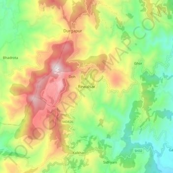
Name: Rewalsar topographic map, elevation, terrain.
Location: Rewalsar, Mandi, Himachal Pradesh, 175023, India (31.59248 76.79330 31.67248 76.87330)
Average elevation: 1,283 m
Minimum elevation: 814 m
Maximum elevation: 1,927 m
Thank you for supporting this site ❤️
Make a donation
Make a donation
Other topographic maps
Click on a map to view its topography, its elevation and its terrain.