
Subotica topographic map
Interactive map
Click on the map to display elevation.
About this map
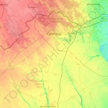
Name: Subotica topographic map, elevation, terrain.
Location: Subotica, Севернобачки управни округ, Voïvodine, Serbie (45.84908 19.28160 46.19028 19.89597)
Average elevation: 111 m
Minimum elevation: 80 m
Maximum elevation: 142 m
La station météorologique de Subotica, qui se trouve à Palić, à quelques kilomètres de la ville, s'élève à une altitude de 102 m ; elle enregistre des données depuis 1936 (coordonnées 46° 06′ N, 19° 46′ E).
Other topographic maps
Click on a map to view its topography, its elevation and its terrain.
Subotica
Serbie > Voïvodine > Севернобачки управни округ
Subotica, Град Суботица, Севернобачки управни округ, Voïvodine, 24000, Serbie
Average elevation: 115 m
Стара Моравица
Serbie > Voïvodine > Севернобачки управни округ > Општина Бачка Топола
Стара Моравица, Општина Бачка Топола, Севернобачки управни округ, Voïvodine, 24340, Serbie
Average elevation: 110 m