
Aragno topographic map
Interactive map
Click on the map to display elevation.
About this map
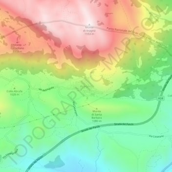
Name: Aragno topographic map, elevation, terrain.
Location: Aragno, L'Aquila, Abruzzo, Italy (42.37637 13.43833 42.41637 13.47833)
Average elevation: 1,072 m
Minimum elevation: 700 m
Maximum elevation: 1,541 m
Other topographic maps
Click on a map to view its topography, its elevation and its terrain.
Fonte Cerreto
Italy > Abruzzo > L'Aquila > L'Aquila
Fonte Cerreto, L'Aquila, Abruzzo, Italy
Average elevation: 1,329 m
Apennine Mountains
Italy > Abruzzo > L'Aquila > L'Aquila
Apennine Mountains, L'Aquila, Abruzzo, Italy
Average elevation: 1,735 m
Campo Imperatore
Italy > Abruzzo > L'Aquila > L'Aquila
Campo Imperatore, L'Aquila, Abruzzo, Italy
Average elevation: 2,056 m