
Make a donation
Istanbul topographic map
Click on the map to display elevation.
Make a donation
About this map
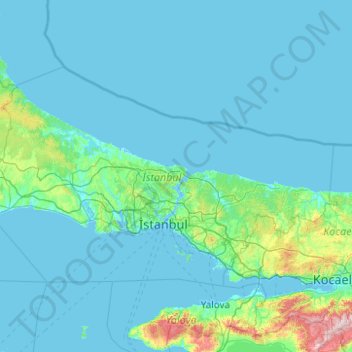
Name: Istanbul topographic map, elevation, terrain.
Location: Istanbul, Marmara Region, Turkey (40.73767 27.97085 41.67100 29.95880)
Average elevation: 74 m
Minimum elevation: -4 m
Maximum elevation: 1,343 m
Make a donation
Other topographic maps
Click on a map to view its topography, its elevation and its terrain.
Make a donation
Make a donation
Make a donation
Make a donation
Gaziantep
The plan introduced several important changes to the city's transportation network. One of the most important was the addition of a rail line to connect Gaziantep to the national rail system. Up to now, Turkish railway construction had ignored Gaziantep (partly because of its mountainous surroundings); a…
Average elevation: 880 m
Eskisehir
Eskişehir has a cold semi-arid climate (BSk) under the Köppen climate classification, and a temperate continental climate (Dc) under the Trewartha climate classification. The city features cold, snowy winters and warm, dry summers. Rainfall occurs mostly during the spring and autumn. Due to Eskişehir's high…
Average elevation: 949 m
Make a donation
Make a donation
Make a donation
Make a donation
Make a donation
Make a donation
Yozgat
Turkey > Yozgat Merkez > Yozgat
The town is located at an elevation of 4,380 ft (1,335 m), situated 105 mi (170 km) east of Ankara, near the head of a narrow valley through which the Ankara–Sivas road runs. Like much of the Anatolian Plateau, the lands around Yozgat have been deforested over thousands of years of human habitation. This…
Average elevation: 1,250 m
Make a donation