
Capanema topographic map
Interactive map
Click on the map to display elevation.
Capanema
'Capanema' is a municipality in the state of Pará. It is located at a latitude 01 ° 11'45 "South and longitude 47 ° 10'51" west, with an altitude of 24 meters. Its population in 2020 was 69,431 inhabitants. Despite being a city average, requires great influence in the region in trade and services. A receptive and lively city, where it became home to many immigrants from various regions of Brazil, mainly from Northeast.
About this map
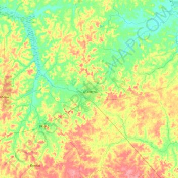
Name: Capanema topographic map, elevation, terrain.
Average elevation: 32 m
Minimum elevation: 0 m
Maximum elevation: 77 m
Other topographic maps
Click on a map to view its topography, its elevation and its terrain.
Marabá
The topography of the municipality of Marabá presents the highest altitudes in the Southeast region of Pará, through the Carajás, Sereno, Buritirama, Paredão, Encontro, Gray and Misteriosa mountains. Of this complex, stands out the Carajás mountain range, like the one of greater size. However, it is in…
Average elevation: 182 m